
Biophysical Products
EOLAB develops innovative biophysical land products mostly related with the vegetation (Leaf Area Index, Fraction of Absorbed Photosynthetically Active Radiation, Vegetation cover, Vegetation Water Content, Vegetation Chlorophyll Content, Crop identification, Above Ground Biomass), which are support tools for many agricultural and environmental applications and the sustainable management of natural resources. These products help quantify environmental variables in space and time and provide valuable information in decision-making processes. Biophysical products are developed from Earth Observation satellite data and state-of-the art algorithms such as non-parametric non-linear regression models (machine learning algorithms) and inversion of canopy radiative transfer models. Our models (empirical or physically-based) can be developed and applied to different remote sensing data at different spatial resolution from few meters (eg., Sentinel-2/MSI) to few kilometers (MSG/SEVIRI, EPS/AVHRR) for local to global applications. At global scale, we are involved in projects related to operational programs such as the Copernicus Global Land Service or the LSA SAF of EUMETSAT. In LSA SAF we collaborate with product developers in the development of algorithms for retrieving vegetation products from MSG and EPS platforms.
You can access here the product portfolio of these services:
Validation and Quality Assessment
Remote sensing products must pass validation and quality assessment to determine the uncertainties attached to the product value and the overall quality to inform users on the fitness-for-purposes of satellite products. Validation mainly involves to evaluate the accuracy and precision of the products, whereas Quality Assessment involves a number of additional test including completeness, spatial and temporal consistency analysis, overall statistical agreement with other products, stability of the time serie, and evaluation of the reliability of error estimates and quality flags among others.
EOLAB offers his expertise to operational services, spatial agencies, and other developers for the product validation and scientific quality assessment. Our main areas of expertise are in the validation of radiation (fluxes, reflectances, albedo) and biophysical variables (LAI, FAPAR, FVC) but similar approaches can be followed for other products. EOLAB contributes to the definition of best practices for validation within the Land Product Validation (LPV) subgroup of the CEOS Working Group on Calibration and Validation (see our publications), and is responsible for the validation of several products in the Copernicus Global Land Service, Copernicus Climate Change Service and EUMETSAT LSA SAF products with many public validation reports available (see our publications).
Our validation methods follows international protocols and standards defined in the context of the CEOS LPV, and the QA4EO project. Furthermore, we are performing research (two PhD ongoing) on validation of albedo and FAPAR products. Recently, we have developed the Surface Albedo Validation tool that provide an operational framework that allows to validate, intercompare, and analyse the fitness-for-purpose of albedo products, while improving the trazability of the validation process (see below).
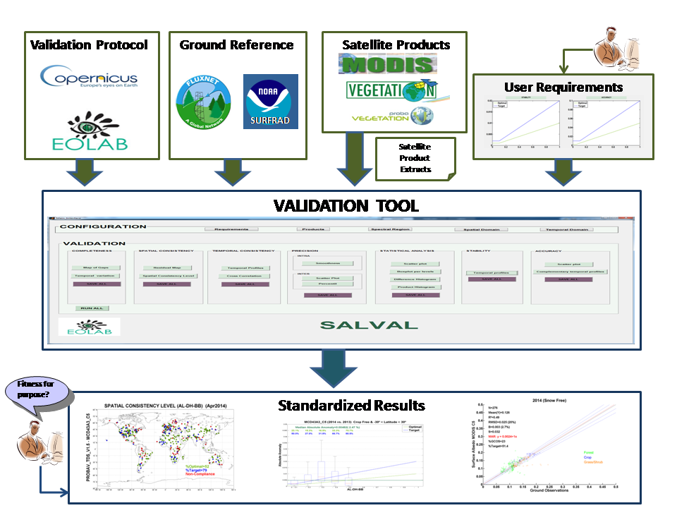
The SALVAL validation tool developed by EOLAB for standardized validation of albedo products.
Accuracy assessment is performed against fiducial reference measurements collected following well established protocols (see Field data collection service). We have available for accuracy assessment large ground database of vegetation and radiation variables collected during the past years.
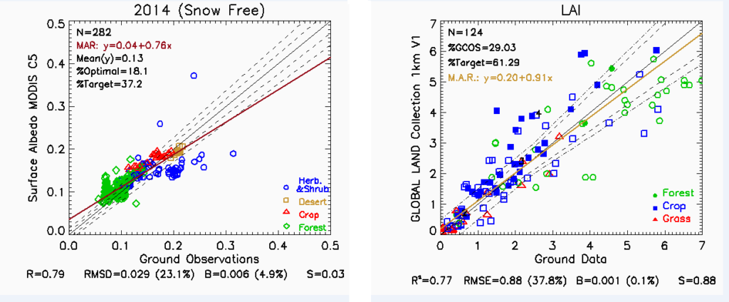
Example of direct validation of MODIS C5 surface albedo (left side) and Copernicus Global Land 1km LAI V1 product (right side)
Field Data Acquisition
EOLAB has extensive experience in participation and coordinate field campaigns. We have several devices to obtain in situ biophysical parameters (LAI, FAPAR, FCover), including hemispherical digital photography, ceptometers and LI-COR LAI 2200C plant canopy analyser.
 We have a Digital camera (CANON EOS 6D and a fisheye converter SIGMA 8mm F3.5 – EX D) to acquire Digital Hemispheric Photographs (DHP). Hemispherical photos allow the calculation of LAI, FAPAR and FCover measuring gap fraction through an extreme wide-angle camera lens. The hemispherical photos acquired are processed with the CAN-EYE software (developed by INRA) to derive LAI, FAPAR and FCover.
- The AccuPAR model LP-80 is a lightweight, portable, linear photosynthetically active radiation (PAR) sensor. It lets you measure canopy PAR interception and calculate leaf area index (LAI) at any location within a plant or forest canopy.
- The LI-COR LAI 2200C plant canopy analyser calculate Leaf Area Index (LAI) and other canopy attributes from light measurements made with a “fish-eye” optical sensor. Measurements made above and below the canopy are used to calculate canopy light interception at five zenith angles, from which LAI is computed using a model of radiative transfer vegetative canopies.
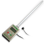
The AccuPAR model LP-80
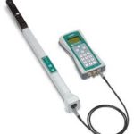
LiCor LAI-2200 PCA
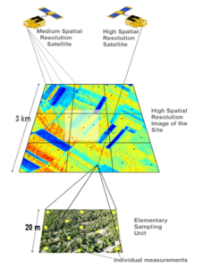
After the ground data collection, EOLAB provide ground-based high resolution maps according to CEOS LPV best practices for validate low and medium resolution products. It consists on a regression method and the selection of the optimal band combination applying empirical functions. We also generate the product Quality Flag by using a convex hull test, providing the level of confidence on the physical values. The mean values and standard deviation are extracted over the 3km x 3km area of the validation sites. They are exploited by the Copernicus Global Land service to assess the quality of the LAI, FAPAR, FCover products derived at 1km and 300m from SPOT/VGT and PROBA-V sensors data.
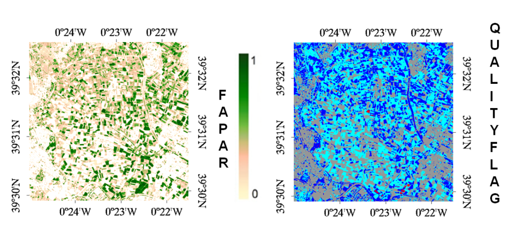
On the left high-resolution ground-based FAPAR map (5×5 km2) over Moncada (Spain) for mid of July 2017. On the right quality flag: clear and dark blue correspond to the pixels belonging to the ‘strict’ and ‘large’ convex hulls; red corresponds to the pixels for which the transfer function is extrapolating; grey corresponds to soil mask.
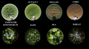
From 2013, EOLAB is responsible for field data collection in the FP7 ImagineS project, directly participating in filed campaigns, or in collaboration with different groups. 66 field campaigns have been conducted over 23 cropland sites during the period from 2013 to 2016. More than 15.000 hemispheric photos have been taken and processed to generate about 160 ground high resolution reference maps. ImagineS makes available the ground measurements of LAI, FAPAR, and FCover collected over demonstration sites and the resulting high resolution maps.
Now, the values of LAI, FAPAR and FCover averaged over 3kmx3km area are gathered in a single file. They are suitable for the accuracy assessment of the kilometric satelite-derived products like the ones delivered by the Copernicus Global Land service. They are also compliant with the OLIVE validation tool.
Climate Change Awareness
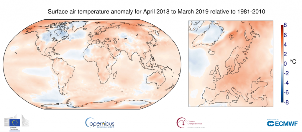
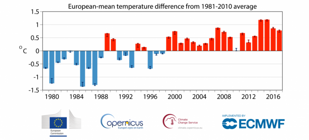
EOLAB provides updated information on Climate Change to students and citizens to increase the climate change awareness in society. Our main source of information is the Copernicus Climate Change Service, in which we are involved, but other sources of trustable data from NASA, scientific publications in high impact journals, or from international organizations as UN IPCC are used. We offer customized presentations to the scientific level of the audience.
Material includes description of the Earth System, the Global Change, Essential Climate Variables, Climate Change drivers: the Green House effect, Earth Observation from Space, Evidences of Climate Change (increase of air temperature, sea level rise, loss of ice extent…), Impacts of Climate Change/Global Change: The second warning to humanity, Climate projections and environmental risks, How we can contribute to mitigation: decarbonization, reforestation, renewable energy, transportation, plant-based food. Examples over your area of interest (land use changes, deforestation/reforestation), and more.
Contact: Dr. Fernando Camacho (fernando.camacho@eolab.es)
Talks are free of charge except for travel costs (talks depending on availability of Dr. Camacho).
See presentation about the contribution of Committee on Earth Observation Satellites in colaboration with UNFCCC to agriculture, forest and other soil uses. (Actions Journal for Climate I [Universitat de Valencia 1/7/2021]):
![]()
Dr.Camacho Interview: Suitainable Climate Change (see).