
Main Projects
EC Copernicus Global Land Service (CGLOPS1) (2016-2026)

The Copernicus Global Land Service (CGLS) is a component of the Land Monitoring Core Service (LMCS) of Copernicus, the European flagship programme on Earth Observation. The Global Land Service systematically produces a series of qualified bio-geophysical products on the status and evolution of the land surface, at global scale and at mid to low spatial resolution, complemented by the constitution of long term time series. The products are used to monitor the vegetation, the water cycle, the energy budget and the terrestrial cryosphere.
Since 2013 the Copernicus Global Land Service delivers geo-biophysical products at global scale with a typical frequency of 10-days.
Tasks:
- Scientific Quality Assessment and Quality Monitoring of Global Land Vegetation, Phenology, Albedo and TOC reflectance products.
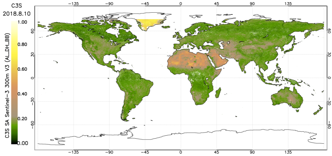
EC Copernicus Climate Change Service (C3S):
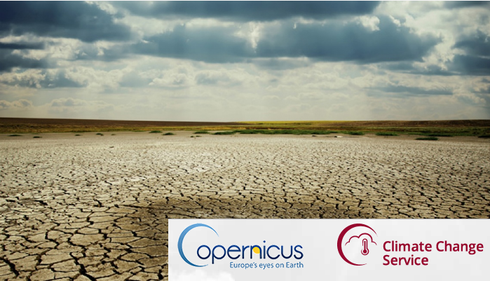
The Copernicus Climate Change Service (C3S) combines observations of the climate system with the latest science to develop authoritative, quality-assured information about the past, current and future states of the climate in Europe and worldwide. Lot 5 is for the production, quality assessment, and user support of Climate data records for land ECVs (i.e., Albedo, LAI, FAPAR, Land Cover and Fire) from remote sensing for the Copernicus Climate Change Service.
Copernicus Services for the provision of C3S_312b Essential Climate Variable products derived from observations – Lot 5 Land biosphere (2018 – 2021; 2022-2024) Tasks:
- Development of Albedo products
- Validation and quality assessment of Albedo, LAI and FAPAR products derived from earth observation data.
- User scientific support.
COP_059 (2020) Tasks:
- Development and validation of the first prototype of surface albedo based on Sentinel-3.
EUMETSAT Land Surface Analysis Satellite Applications Facility CDOP 4 (2022-2027)
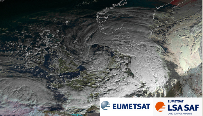
Land-SAF is aimed to provide in near real time geobiophysical variables from EUMETSAT satellites. The main objective in CDOP-4 is to provide service continuity and the transition from MSG to MTG and from EPS to EPS-SG.
Tasks:
- Technical assistance to the University of Valencia for developing of retrieval methodologies.
- Validation of biophysical products.
Fiducial Reference Measurements for Vegetation (FRM4VEG) (2017-2023)
The overall aim of this project is to support the initial validation of Copernicus vegetation-related products from Sentinel-3 (FAPAR, OTRCI and SYN), Sentinel-2 (L2A) and PROBA-V (S1 TOC 100m), as well as proposing the methodologies for the definition of the required Fiducial Reference Mesurements (FRM). See video of the project.
This project is an early development stage that ultimately provides confidence to users in their application of satellite derived vegetation products, as a result of increased confidence in core products from using a consistent and SI traceable set of independent in-situ measurements.
Tasks:
Phase 1:
- Campaign Execution.
- Predeployment calibrations.
- Instrument intallation.
- Initial verification.
- Execute field campaigns with in-situ ground and airborne measurements.
- Campaign Execution.
- Campaign data processing and delivery.
- Process and quality control the campaign data following documented FRM procedures to approve their use for satellite validation.
- Campaign data processing and delivery.
Phase 2:
- The planning, preparation and execution of one round robin inter-comparison exercise.
- To bring together several validation teams.
- Discussion on instruments calibration, sites characterization, FRM protocols, upscaling, etc.
- Achieving a common understanding and agreement on FRM protocols and procedures.
- Selection of two sites in Europe and definition of a set-up plan for systematic FRM FAPAR measurements over permanent sites, to make them become part of the network of Land Products Validation Supersites, as defined by CEOS WGCV LPV.
- The planning, preparation and execution of one round robin inter-comparison exercise.
Climate Change Iniciative (CCI) Vegetation (2022-2025)
![]()
The Climate Change Iniciative (CCI) project aims to realise the full potential of the long-term global Earth Observation archives that ESA has established over the past 30 years, as a significant and timely contribution to the Essential Climate Variables (ECV) databases required by United Nations Framework Convention on Climate Change (UNFCCC).
This contract expands the ESA CCI portfolio with two additional ECVs: one-sided leaf area index (LAI) and the fraction of incident surface solar radiation in the photosynthetically active region (0.4-0.7 μm) absorbed by vegetation (FAPAR). These variables are widely used as model state variables of the land surface: for estimation of surface energy and water budgets, carbon sequestration, and phenological responses.The final goal of the CCI program is to transfer the developed data sets and processing systems to operational production outside CCI such as the Copernicus Climate Change Service (C3S).
The objective of the project is to develop a dataset and a processing chain for global, multi-decadal time series of LAI and FAPAR that is both ready for operational use, and that has demonstrated added value for the climate science community.
Tha project novelty is the maximizing of the use of EO data: The final data sets will cover the global land mass for the period 2000-2021 at 1 km and 300m and will be based on the optimal joint retrieval of the following sensors:
- SPOT4/VGT1 and SPOT5/VGT2
- Terra/MODIS and Aqua/MODIS
- ENVISAT/MERIS
- Metop-A/B/C-AVHRR
- PROBA-V
- Sentinel-3/OLCI
- VIIRS
EOLAB Tasks:
Scientific Quality Assessment of the vegation (LAI and FAPAR) products.
RemoTrees (2023-2027)
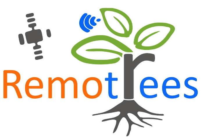 The overall goal of RemoTrees project is to develop and test a new in-situ observation system based on Internet of Things (IoT), technology and satellite communication, specifically designed for hard-to-reach forest areas.
The RemoTrees system will address the lack of in-situ data for hard-to-reach forest and complement Earth Observation (EO) efforts to monitor climate change effects on these ecosystems.
EOLAB are involved in the following tasks:
Data-access and visualization.
- RemoTrees platform interoperability: Integration framework and demostration of the project outputs within the GEOSS platform and the Copernicus Core Services.
- Interface with Copernicus Services and international validation programs.
- Customise the RemoTrees data to fit the Copernicus needs.
- Upscaling raw data to generate Land Products (LP) using Sentinel-2 products.
- Deviler customised data and technical documentation.
Quality Assurance for Earth Observation (QA4EO-2) (2024-2025)
![]()
In response to CEOS WGCV (cv-12) action, ‘the evaluation of well-characterized supersites for validation purposes”, EOLAB is the responsible to identify CEOS supersites for land product validation considering additional actions from the GCOS Implementation Plan 2016.
EOLAB main tasks:
- Identification of supersites, which must be super characterized (canopy structure and bio-geophysical variables), follow the protocols useful for the validation of satellite land products (at least 3 products) and radiative transfer model approaches. In addition, they must be active at long-term and, if possible, supported by airborne LiDAR and hyperspectral acquisitions.
- The supersites were primarily selected from well-known networks, as National Ecosystem Observatory Network (NEON), Integrated Carbon Observation System (ICOS) and Australian Terrestrial Ecosystem Research Network (TERN) and were complemented with others as Copernicus Ground-based Observations for Validation (GBOV).
- The sites were also ranked according to the global region, representativeness, structural information and by other properties measured in the site.
Other Projects
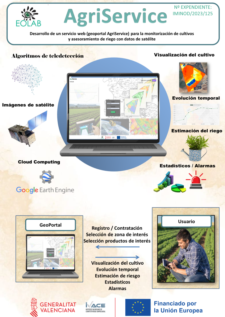
The main objective of AgriService is to develop a GeoPortal (web tool) which offers a service for crop monitoring and irrigation advice. The service allows users to access in real time to the agronomic information obteined from high resolution satellite earth observations (Sentinel-2). The portfolio includes: Vegetation index (NDVI), Biophysical variables (FCOVER), Land Surface Temperature of the crop (LST) and evoptranspiration (ET).
Tasks:
- To develop a GeoPortal to integrate the product portfolio, using cloud computing technologies (Google Earth Engine).
- To provide access to the maps and temporal series of the products.
- To create a register platform and parcel selection for users.
This project is an innovation TEICs solutions developed within the framework of IVACE INNOVATeiC-CV program.
Access here: http://agriservice.eolab.es

 The High Resolution Vegetation Phenology and Productivity (HR-VPP) Monitoring is a component of the Copernicus Land Monitoring Service. It includes the implementation, operation, delivery and promotion of the HR-VPP component on behalf of the European Environment Agency (EEA) and in accordance with predefined end user requirements. The products include raw daily Vegetation Indices (e.g. NDVI, LAI, FAPAR) and yearly Seasonal Trajectories and Phenology/Productivity parameters. Their prime use is for ecosystem analysis and to provide input to a wide range of other derived services (land cover mapping, crop monitoring, etc.).
Tasks:
- To provide and performance an independent internal thematic validation.
The main objective of AGRISEN-123 is to create an efficient crop management tool from the estimation of biophysical and thermodynamic variables of the vegetation and the crop classification, by means of the synergistic use of satellite Sentinel 1, 2 and 3. Important issues as the hydrological or recovering needs of the crops at high spatiotemporal frequency will be addressed in this project.
Tasks:
- Collection of ground and satellite data.
- Generation of algorithms to estimate biophysical and thermodynamic variables, and crop classification.
- Implementation of a crop management tool regarding hydrological or recovering needs of the crops.
This project will take place in the EOLAB installation, in the 2019-2022 period, with a budget of 189.652 €, supported with CDTI and FEDER funds.

EUMETSAT Land Surface Analysis Satellite Applications Facility CDOP 3 (2017-2022)
Land-SAF is aimed to provide in near real time geobiophysical variables from EUMETSAT satellites. The main objective in CDOP-3 is to operate current MSG and EPS/AVHRR products, and to prepare the transition to Meteosat Third Generation (MTG).
Tasks:
- Technical assistance to the University of Valencia for developing of retrieval methodologies and its validation.
- Quality assessment of NDVI products based on Surface Albedo.
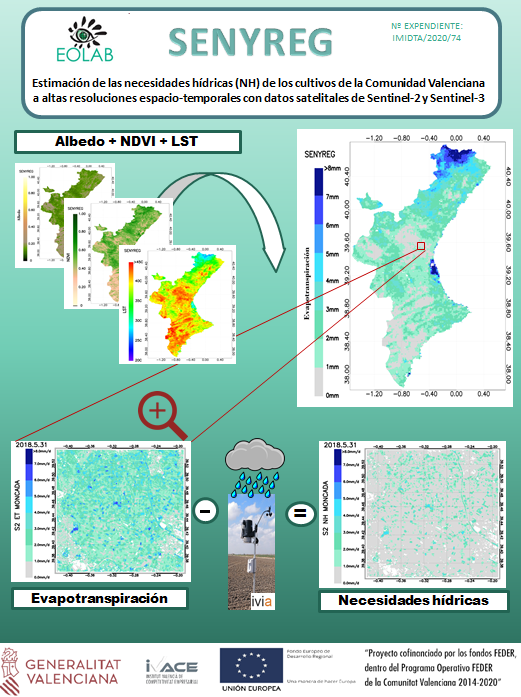 SENYREG is based on the estimation of the water needs (NH), evapotranspiration (ET) and Land Surface Temperature (LST) at median resolution (300m) over Comunidad Valenciana using Sentinel-3 and at high resolution (10/20m) over some fileds (Moncada and Requena-Utiel) using Sentinel-2. It was co-financed by the Valencian Insitute of Business Competitiveness (IVACE) with FEDER funds from the European Union.
Tasks:
- To obtain an LST product at 10m resolution using the MSI sensor on board Sentinel-2, with the synergistic study of Sentinel-2 with Landsat-8 and Sentinel-3 (the MSI on board Sentinel-2 does not have thermal bands).
- To estimate the ET at a field level resolution (Sentinel-2) and regional level resolution (Sentinel-3).
- To create agro-meteorological maps , using a kriggring (geostatistical technique) to extend the stations meteorological data to the entire Valencian territory.
- To create water needs (NH) maps in the whole Comunitad Valenciana territory (at 300m resolution) and in some fields areas as Moncada and Requena (at 10m resolution).
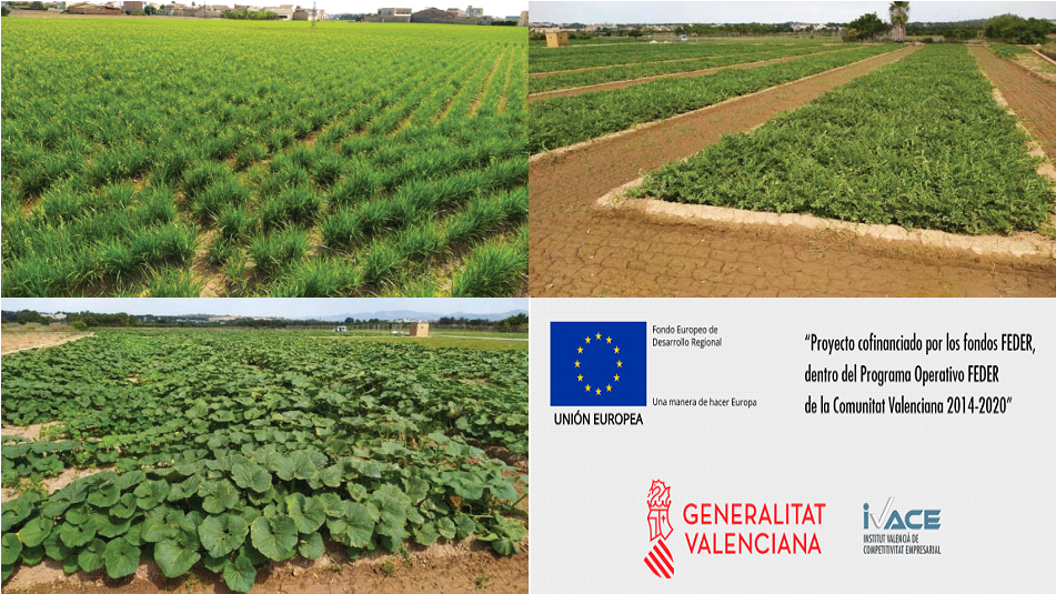 CULTISAT is aimed to discriminate and classify crops using high spatial resolution Sentinel-2 satellite data. It was co-financed by the Valencian Insitute of Business Competitiveness (IVACE) with FEDER funds from the European Union.
Tasks:
- Collection of satellite Sentinel-2 images and ground data with dedicated field campaigns.
- Implementation and comparison of machine learning methods for the classification of different types of crops.
- Monitoring crop discrimination and classification of different agricultural areas over Barrax (Albacete) and mainly over Moncada (Valencia).
Main results: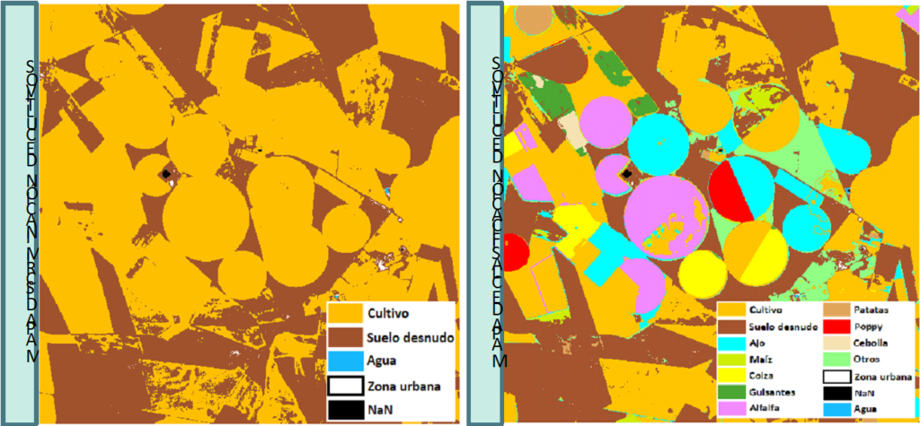
Monthly field campaigns were carried out over Moncada (Valencia) during the end of 2019-and almost all 2020, with the inventorying of more than 100 different types of crops. Also, in 2019 a campaign in Barrax (Albacete) was conducted to alternatively classify crops, different of Moncada (Valencia).
After the study of several machine learning methods, Random Forest (RF) method has achieved the best results with correlations higher than 0.98 and being the most robust method.
Final results of CULTISAT show plausible monthly maps for crop discrimination and preferable crop classification every 3 months.
 The main objective of SEN2MED is to estimate the existence of biomass and the Carbon capture and storage by the forest trees (mostly Pinus Halepensis), to improve the current forest management tools regarding the fire risk prevention and decreasing the risks inherent to the climate change. This objective is achieved by using high spatial resolution Sentinel-2, improved with LiDAR flights carried out by the PNOA. This project has been co-financed by the Valencian Institute of Business Competitiveness (IVACE) with FEDER funds from the European Union.
Tasks:
- Collection of ground and satellite data.
- Generation of algorithms to estimate biomass and Carbon storage
- Comparison of machine learning methods for the estimation of biomass and Carbon storage.
- Forest analysis (validation with reference inventories).
Main results: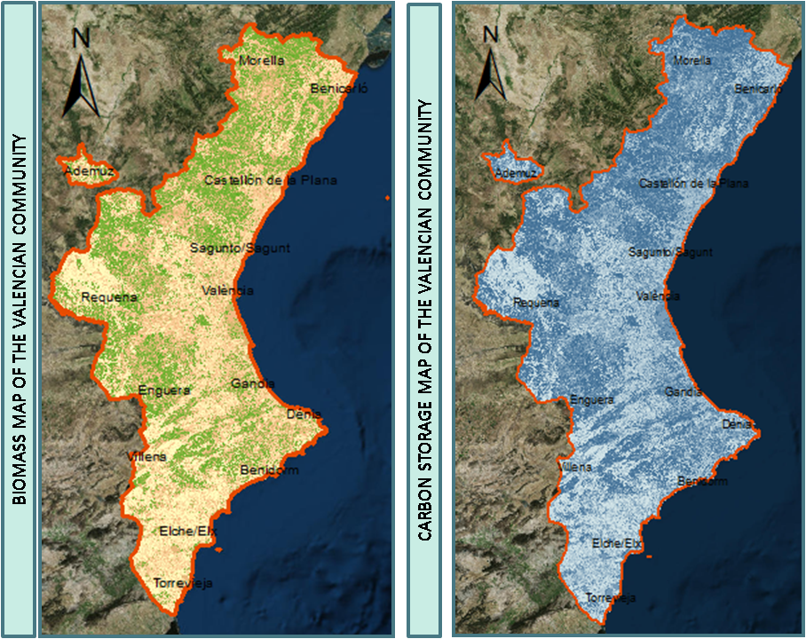
Two field campaigns were carried out over Lliria and Enguera (Valencia) during the 2018 year sampling dendrometric variables for different forest structures.
After the study of several machine learning methods, Gaussian Process Regression (GPR) method has achieved the best results with correlations higher than 0.88, combining the band 8A and the NDVI product of Sentinel-2.
A biomass and Carbon storage maps were obtained as results of SEN2MED, which showed the commercial potential of this project for the private sector, since is the owner of the 90% of Mediterranean.
SECUSEN2 is aimed to estimate biophysical variables for crop monitoring using high spatial resolution Sentinel-2 and Landsat-8 satellite data. It was co-financed by the Valencian Institute of Business Competitiveness (IVACE) with FEDER funds from the European Union.
Tasks:
- Collection of ground data.
- Comparison of machine learning methods for the estimation of biophysical variables.
- Crop monitoring of different agricultural areas.
Main results:
- Three campaigns were carried out over Moncada (Valencia) during the 2017 year with more than 15 different types of crops. Also, in 2018 a campaign in Barrax (Albacete) was conducted.
- After the study of several machine learning methods, Gaussian Process Regression (GPR) method has achieved the best results with correlations higher than 0.8 and being the most robust method.
- Temporal profiles of LAI, FAPAR and FCOVER over three different agricultural areas have been studied and validated with recent ground measurements.
- The final results of SECUSEN2 show the commercial viability and the evolution of this project is plausible so next steps could be to include meteorological data and a web viewer to better visualize the satellite information.

EC Copernicus Climate Change Service (C3S) Lot 9 (2016-2018)
The Copernicus Climate Change Service (C3S) is still in the development phase and will combine observations of the climate system with the latest science to develop authoritative, quality-assured information about the past, current and future states of the climate in Europe and worldwide.
Tasks:
- Scientific Quality Assessment of Climate Data Records of Surface Albedo, LAI and FAPAR Essential Climate Variables.
Current state:
- Albedo version v0, v1 (AVHRR, SPOT-VGT and PROBA-V) available via link
- LAI/FAPAR version v0, v1 (AVHRR, SPOT-VGT and PROBA-V) available via link
EC Copernicus Global Land Service (GIO-GL) (2013-2017). Since 2013 the Copernicus Global Land Service delivers geo-biophysical products at global scale with a typical frequency of 10-days.
Tasks:
- Scientific Quality Assessment and Quality Monitoring of Global Land vegetation, albedo and TOC reflectance products.
- User support and training activities.
 EUMETSAT Land Surface Analysis Satellite Applications Facility CDOP-2 (2012-2017). Land-SAF is aimed to provide in near real time geobiophysical variables from EUMETSAT satellites. The main objective in CDOP-2 is to develop global products from EPS/AVHRR data.
Tasks:
- Technical assistance to the University of Valencia for developing of retrieval methodologies and its validation.
![]()
FP7 Implementation of multi-scale agricultural indicators exploiting Sentinels (2013-2014). The objective of ImagineS project is to prepare processing lines for PROBA-V and Sentinels data for retrieval of biophysical variables and agricultural indicators within Copernicus Global Land Service.
Tasks:
- User Interface.
- Collection of ground data.
- Generation of empirical high resolution maps.
- Scientific Validation of vegetation and albedo products.
- Training activities.
Copernicus User Uptake (2013-2014). In order to support the adoption of Copernicus services by user communities, several «User Uptake» activities funded by the European Commission were carried out in 2013 and 2014.
Tasks:
- Support to the User Uptake of Copernicus Global Land products.
ESA Explotation of ESA campaigns for Sentinel-2 Level2 Validation (VALSE-2) (2012-2013). VALSE-2 was aimed to validate algorithms for retrieving biophysical variables from Sentinel-2 like data.
Tasks:
- Analysis of ground data in ESA field campaigns.
- Validation of S2 prototype algorithms to retrieve biophysical (LAI, FAPAR, Water Content, Ch) parameters.
 FP7 geoland-2 (Towards an Operational Land Monitoring Core Service) (2008-2012). Geoland2 was carried out in the context of the GMES, which aims to build up a European capacity for Global Monitoring of Environment and Security.
Tasks:
- Scientific validation of radiation (DSSF, albedo) and vegetation (LAI, FAPAR, FCover) global products.
EUMETSAT Land Surface Analysis Satellite Applications Facility CDOP (2008-2012). Land-SAF is aimed to provide in near real time geobiophysical variables from EUMETSAT satellites.
Tasks:
- The upgrade of vegetation variables (mainly FAPAR) from MSG composite products and preparation for EPS/METOP data, its continuous scientific validation and the promotion among operational users
![]()
CICYT (Spain) ARTEMIS (2009-2012).
Tasks:
- EOLAB has developed the FAPAR product based on MODIS data at 500m. The algorithm relies on the inversion of a heterogeneous canopy radiative transfer model (4SAIL2) coupled with PROSPECT for the leaves.
![]()
CICYT (Spain) MIDAS.5 (2008-2010)
Tasks:
- Characterization of the vegetation canopy water content (CWC) over the Utiel-Requena SMOS validation area.

ESA SEN3EXP (2009). The SEN3EXP ESA Campaign provide a comprehensive dataset based on airborne hyperspectral measurements, satellite data from ENVISAT MERIS and AATSR as wel as from other space platforms, and correlative ground measurements. See SEN3EXP Final Report.
Tasks:
- Ground data acquisition of vegetation variables (LAI, FAPAR, FCover and plant water content) during the Barrax campaign.
- Generation of empirical high resolution maps.
- Radiative transfer model and artificial neural networks methods were used for retrieval of biophysical variables from CHRIS/PROBA data.
EUMETSAT Land Surface Analysis Satellite Applications Facility IOP (2006-2008). Land-SAF is aimed to provide in near real time geobiophysical variables from EUMETSAT satellites.
Tasks:
- EOLAB was in charge of developing the FAPAR product based on MSG/SEVIRI data for Land-SAF. The prototype was calibrated against similar FAPAR products (MODIS, CYCLOPES,POLDER, MERIS) and implemented.
![]() FP6 Vegetation for Africa (2006). VGT4Africa was a FP6 SSA project, with the objective to assuring of the distribution in real time of biophysical products based on VGT data in support of sustainable development policies in Africa and the AMESD program.
FP6 Vegetation for Africa (2006). VGT4Africa was a FP6 SSA project, with the objective to assuring of the distribution in real time of biophysical products based on VGT data in support of sustainable development policies in Africa and the AMESD program.
Tasks:
- Technical assistance for the FCover product with SPOT/VGT data.
![]()
CICYT (Spain) MIDAS.4 (2006)
Tasks:
- Characterization of LAI, FVC and FAPAR over the Utiel-Requena SMOS validation area.
In 2010s, the CEOS WGCV established a CEOS Cal/Val action (cv-12) aimed to evaluate validation…

The leaf area index (LAI) and the fraction of absorbed photosynthetically active radiation (FAPAR) by…
EOLAB is a beneficiary of the MOVES III program from the Instituto Valenciano De Competitividad…

Jorge Sánchez-Zapero has been chosen as the new co-lead of the Committee on Earth Observation…
The aim of Copernicus Climate Change Service (C3S) is to supply access to reliable climate…