
SALVAL
The overall aim of SALVAL is to bring together validation good practices protocols, ground data and satellite products to provide users with traceable (i.e. reproducible) validation results allowing reaching CEOS WGCV LPV validation Stage 4.
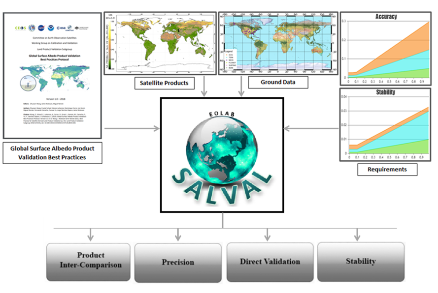
The SALVAL (Surface Albedo VALidation) tool provides the user with:
- A user-friendly interface for comparison of new satellite-based land surface albedo data products against ground reference data and existing validated land surface albedo products.
- A traceable, transparent, and consistent methodology following the CEOS WGCV LPV Surface Albedo validation good practices protocol for conducting the validation exercise.
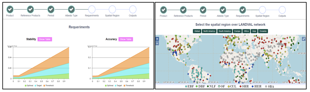
- A flexible tool that allows for setting up the exercise with user defined requirements, albedo quantities, extents, or periods of interest to analyse results either interactively (via graphs and maps) or creating a standardized validation report in pdf format.
- A tool to benchmark new products, update product validation results or add new ground reference data.
SALVAL has the following components:
- Protocols and validation methodology from community-agreed protocols and standards defined by the Land Product Validation (LPV) subgroup of the Working Group on Calibration and Validation (WGCV) of the Committee on Earth Observation Satellites (CEOS) (Wang et al., 2019) and by the Quality Assurance framework for Earth Observation (QA4EO). Methods are based on two main approaches: direct validation of satellite products with in-situ measurements and satellite products inter-comparison over a global sampling of sites. See sampling database description.
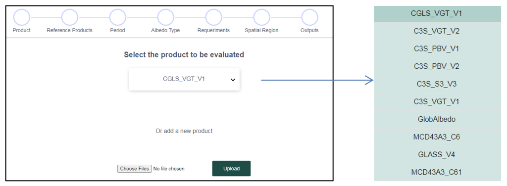
- A Surface Albedo satellite products database (NASA, COPERNICUS/EU C3S, ESA GlobAlbedo, China GLASS) and the possibility to import a new dataset.
- A unique high quality-controlled sub-set of in-situ measurements selected from 99 tower-based stations which match CEOS LPV standards for validation (spatial representativeness).
- The possibility to specify user requirements for evaluating the fit-for-purpose of the evaluated products in terms of stability or accuracy over global or continental areas.
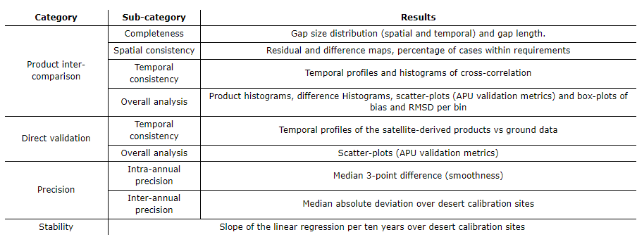
The tool allows evaluating different criteria, such as product continuity, temporal and spatial consistency, statistical agreement with other similar products, precision, stability and accuracy by comparison with independent measures in situ, among others (see a summary in the table below).
References:
Wang, Z., Schaaf, C., Lattanzio, A., Carrer, D., Grant, I., Roman, M., Camacho, F., Yang, Y., Sánchez-Zapero, J., 2019. Global Surface Albedo Product Validation Best Practices Protocol. Version 1.0. In Z. Wang, J. Nickeson & M. Román (Eds.), Best Practice for Satellite Derived Land Product Validation (p. 45): Land Product Validation Subgroup (WGCV/CEOS), doi: 10.5067/DOC/C [WWW Document]. https://doi.org/doi: 10.5067/DOC/CEOSWGCV/LPV/ALBEDO.001
Getting started.
Follow these steps to start using SALVAL:
1) Sign up to start using the SALVAL tool, free of charge available at www.salval.eolab.es

2) Specify the product being validated and the reference products. Select from existing database of products or import new products.
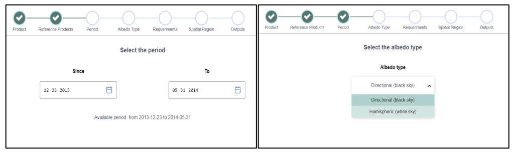
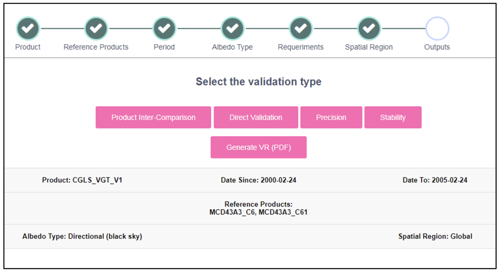
3) Define the input product: time period, albedo type, requirements and spatial coverage.
4) Visualize the validation results for different criteria, or generate standardized validation report in PDF.
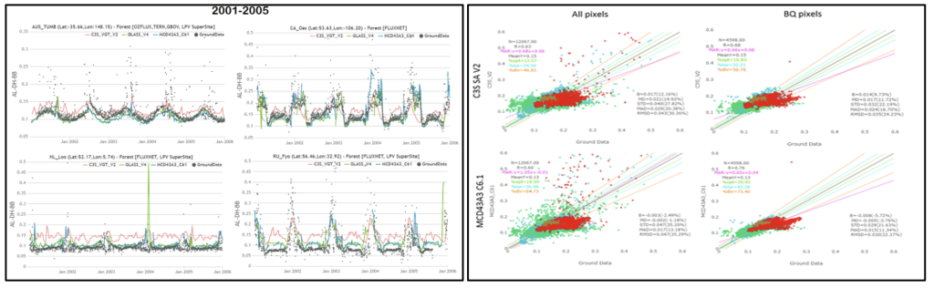
5) Enjoy the interactive validation process (see below Direct Validation type results).
More technical details about tool functionalities, satellite reference products, in-situ datasets, etc., can be found in the SALVAL user guide.
The validation and intercomparison exercise are performed over two different ensembles of sites:
- REALS (Representativeness-Evaluated ALbedo Stations): These are a collection of 99 sites where the direct point-to-pixel comparison was assessed, which involves direct comparison of medium resolution satellite product pixels with albedo measured from in situ tower-based instruments. The spatial representativeness of the in situ albedometer footprint was evaluated for the satellite pixel according to CEOS LPV good practices adopted for validation ( Román et al., 2009, 2010).
- LANDVAL (Land validation): These sites are a sampling of 720 homogeneous sites used for a satellite product-to-product validation approach, referred to as satellite product intercomparison. LANDVAL was designed to globally represent the variability of land surface types (Fuster et al., 2020; Sánchez-Zapero et al., 2020). LANDVAL includes CNES desert calibration sites (Lachérade et al., 2013) for precision and stability evaluation.
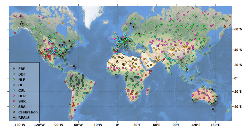
Figure. Global distribution of 99 REALS and 720 LANDVAL sites. LANDVAL are displayed per biome type: EBF stands for evergreen broadleaved forest, DBF for deciduous broadleaved forest, NLF for needle-leaf forests, OF for other forests, CUL for cultivated, HER for herbaceous, SHR for shrublands, and SBA for sparse and bare areas.
References:
- Fuster, B., Sánchez-Zapero, J., Camacho, F., García-Santos, V., Verger, A., Lacaze, R., Weiss, M., Baret, F., & Smets, B. (2020). Quality Assessment of PROBA-V LAI, fAPAR and fCOVER Collection 300 m Products of Copernicus Global Land Service. Remote Sensing, 12(6), 1017. https://doi.org/10.3390/rs12061017
- Lachérade, S., Fougnie, B., Henry, P., Gamet, P., Lacherade, S., Fougnie, B., Henry, P., & Gamet, P. (2013). Cross calibration over desert sites: Description, methodology, and operational implementation. IEEE Transactions on Geoscience and Remote Sensing, 51(3), 1098–1113. https://doi.org/10.1109/TGRS.2012.2227061
- Román, M. O., Schaaf, C. B., Lewis, P., Gao, F., Anderson, G. P., Privette, J. L., Strahler, A. H., Woodcock, C. E., & Barnsley, M. (2010). Assessing the coupling between surface albedo derived from MODIS and the fraction of diffuse skylight over spatially-characterized landscapes. Remote Sensing of Environment, 114(4), 738–760. https://doi.org/10.1016/j.rse.2009.11.014
- Román, M. O., Schaaf, C. B., Woodcock, C. E., Strahler, A. H., Yang, X., Braswell, R. H., Curtis, P. S., Davis, K. J., Dragoni, D., Goulden, M. L., Gu, L., Hollinger, D. Y., Kolb, T. E., Meyers, T. P., Munger, J. W., Privette, J. L., Richardson, A. D., Wilson, T. B., & Wofsy, S. C. (2009). The MODIS (Collection V005) BRDF/albedo product: Assessment of spatial representativeness over forested landscapes. Remote Sensing of Environment, 113(11), 2476–2498. https://doi.org/10.1016/j.rse.2009.07.009
- Sánchez-Zapero, J., Camacho, F., Martínez-Sánchez, E., Lacaze, R., Carrer, D., Pinault, F., Benhadj, I., & Muñoz-Sabater, J. (2020). Quality Assessment of PROBA-V Surface Albedo V1 for the Continuity of the Copernicus Climate Change Service. Remote Sensing 2020, Vol. 12, Page 2596, 12(16), 2596. https://doi.org/10.3390/rs12162596