
EOLAB Datasets
Ground Data
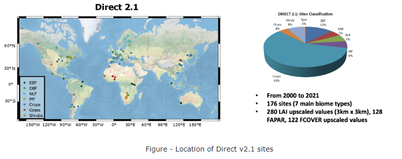
CEOS LPV DIRECT V2.1: A database of upscaled LAI, FAPAR and Fcover values for satellite biophysical product validation
Ground references of high quality are needed to validate satellite-based products. The DIRECT V2.1 database compiles Leaf Area Index (LAI), fraction of absorbed photosynthetically active radiation (FAPAR) and fraction of vegetation cover (FCover) averaged values over a 3 km x 3 km area. The ground data was upscaled using high spatial resolution imagery following CEOS WGCV LPV (so called CEOS LPV) LAI validation good practices (Fernandes et al., 2014) to properly account for the spatial heterogeneity of the site. Ground measurements performed during several international Cal/Val activities, including VALERI, BigFoot, SAFARI-2000, CCRS, Boston University, were compiled by S. Garrigues (Garrigues et al., 2008) in the DIRECT database, and later ingested in the CEOS LPV OLIVE tool (Weiss et al., 2014) for accuracy assessment….see more on 10.5281/zenodo.11235157
Camacho, F., Sánchez-Zapero, J., Fang, H., Weiss, M., & Brown, L. (2024). CEOS LPV DIRECT V2.1: A database of upscaled LAI, FAPAR and Fcover values for satellite biophysical product validation [Data set]. Zenodo. https://doi.org/10.5281/zenodo.11235157
Networks
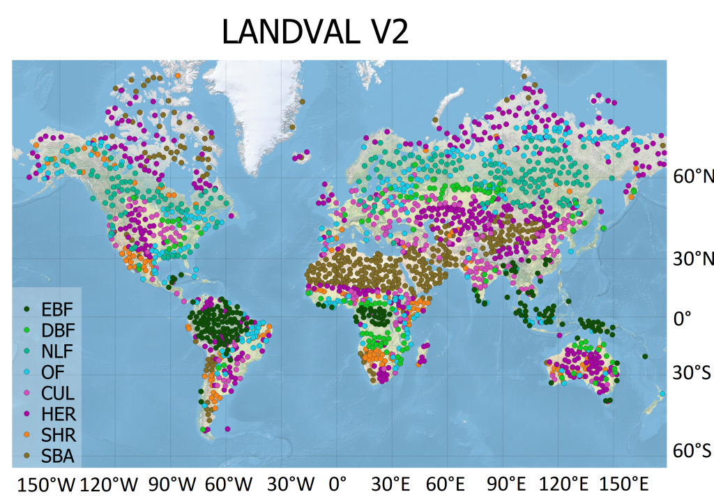
LAND VALidation (LANDVAL) V2: Representative global sampling for satellite product intercomparison and calibration
The LAND VALidation (LANDVAL) V2 network of sites was generated with a semi-automatic algorithm developed in Python open source code to provide a global sampling representative of global conditions in term of land cover, continental area and ecoregion. The source code needs the following inputs provided by the user: number of samples of the final dataset and the global maps used to classify the global conditions in terms of land cover and ecoregion…..see more on 10.5281/zenodo.10559901
Martínez-Sánchez, E., Sánchez-Zapero, J., & Camacho, F. (2024). LAND VALidation (LANDVAL) V2: Representative global sampling for satellite product intercomparison and calibration [Data set]. Zenodo. https://doi.org/10.5281/zenodo.10559901
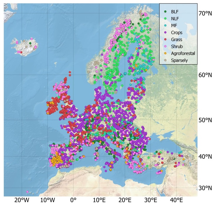
European eVALuation sites (EVAL): A European sampling for regional satellite product intercomparison
For the quality assessment of satellite-based products it is necessary to perform product intercomparisons at global and continental scales. In the context of the Copernicus Land Monitoring Service High-Resolution Vegetation and Productivity Parameters (HR-VPP) project, a network of European eVALuation (EVAL) sites was defined to perform product intercomparisons over a representative sampling in terms of land cover and geographical area. EVAL is thus a spatial sampling of 3800 evaluation sites over the 39 countries of the European Economic Area (EEA39) [1]. The main selection criterium is the homogeneity, in terms of land cover, over areas of 1 km x 1 km (more than 70% of the area corresponds to the same land cover class) to be useful for the evaluation of decametric and hectometric (300 – 500 m) resolution products…see more on 10.5281/zenodo.1125601
Camacho, F., Sánchez-Zapero, J., Martínez-Sánchez, E., & Roses, C. (2024). European eVALuation sites (EVAL): A European sampling for regional satellite product intercomparison [Data set]. Zenodo. https://doi.org/10.5281/zenodo.11125601